Showing posts with label Running in America. Show all posts

Saturday, April 19, 2025

Freezing but wonderful Bryce Canyon: my favorite!

I only visited 30 of the 63 National Parks in the US but, so far, Bryce Canyon remains my favorite. Especially in winter with the rich palette of colors include white snow, contrasting with the red rocks and blue sky. And the brittle aspect and impression of fragility of the hoodoos, this canyon which looks like temporary dentelle ready to be washed out by erosion and the elements, wind and rain, if not earthquakes. Million year-old yet, in this age of severe human impact on our planet, you have to wonder how long this natural show will last. You see, I'm sold!


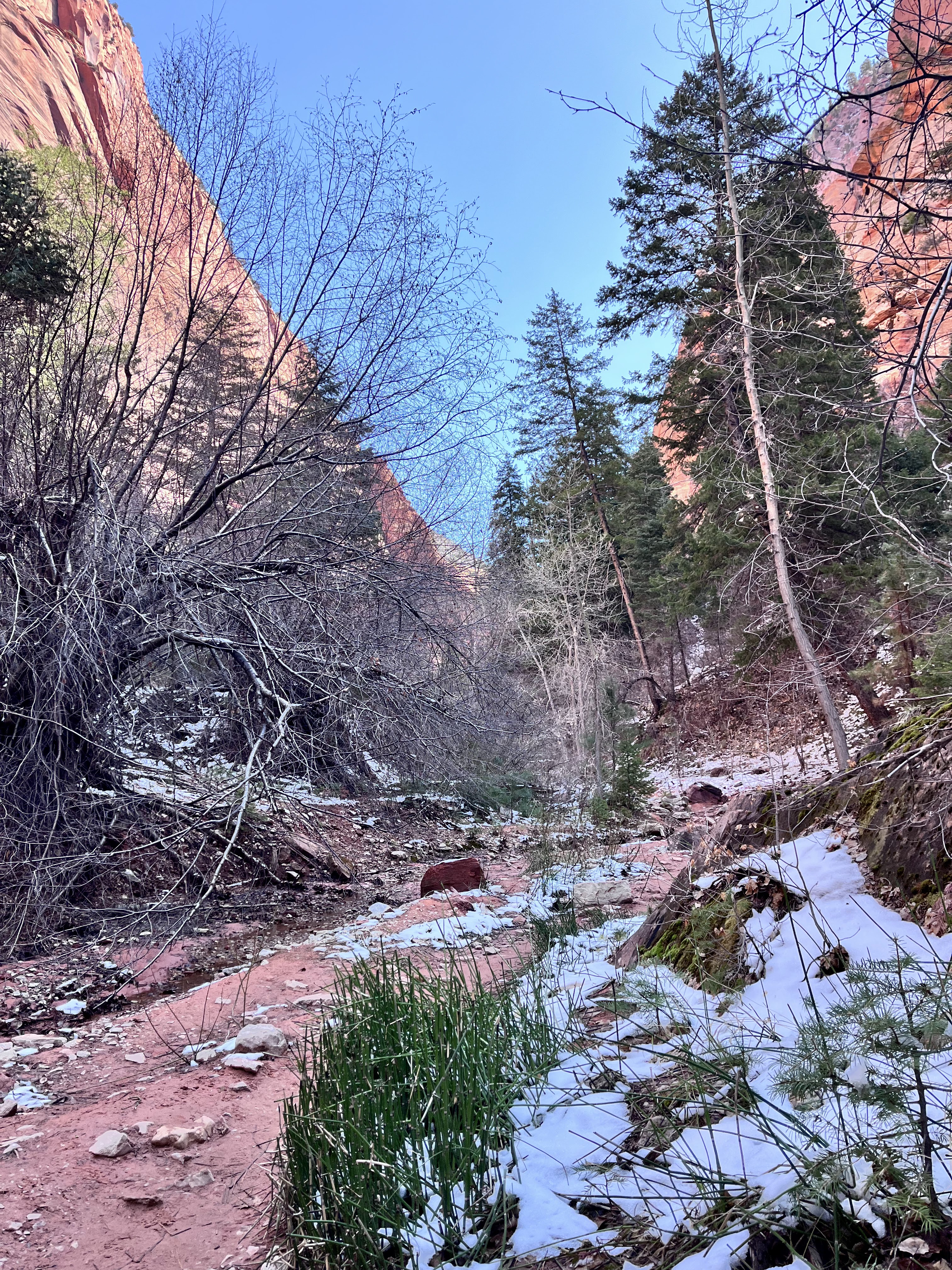
It was my third visit and, this time, I wanted to go down the canyon, not just stay on the ridge. It was a family trip again though so I had to start super early, like before sunrise. And, although it was April already, and Spring, technically, the temperature was close to 20F when I left the hotel, yikes! If you follow my blog and adventures, you know I fare poorly when chilly. By the way, there was a freezing breeze to make things more interesting.

Thinking I would warm-up with speed, I left with only a pair of racing gloves, leaving my bigger fleece gloves in the room. Poor choice. Ever quarter of a mile, in the dark, I had to stop to put my bottles down and blow air through my gloves as my fingertips were badly hurting. And the more I was stopping, the colder I was getting...

Sunrise was scheduled for 7:05 am. I left the hotel in Bryce Canyon village at 6 and my initial plan was to run straight to the end of the Bryce Canyon amphitheater, at Bryce Point, 7 miles away. With the slow progress, I decided to change plan and aim at meeting Agnès and my cousins/aunt at Sunrise Point instead, making a detour through Fairyland Point to then run along the entire ridge of the canyon, before plunging into it at Bryce Point, on Peekaboo Loop Trail.


While I did manage to get to Sunrise Point by sunrise, I wasn't getting warmer after the Sun rose because a thin layer of clouds maintained the low temperature. It helped a bit to get the extra pair of gloves but I needed way more than that bit to be able to run normally. To make the matter more interesting, the ridge trail was covered by icy snow on the steep way up to Inspiration Point, then Bryce Point. The Brooks Pure Grit worked wonder in these conditions, it's just that I was too cold to keep moving.


The wind was strong at Bryce Point: on one hand the views of the amphitheater were stunning and I had to remove my gloves to take pictures. On the other, the cold was unbearable. I wouldn't fare well on Mount Everest...


The plan was for me to be back to the hotel by 9:15 to grab breakfast and it was already 8 am. I ran a couple of mile on the road then heard the Park Shuttle coming: I waived at it, on its side of the road and, zip, it didn't stop. I appreciate I wasn't at the parking lot stop but, geez, I was freezing. Cold. Damned! A few minutes later, a car came through and I waved at it too: two girls driving, I understand the reluctance to pick a stranger. At that point, I called Agnès for a pick up...


The following Relive.cc flyover includes pictures from all the key points: Faryland, Sunrise, Sunset, Inspiration and Bryce Points. Click on this link or the image below.


10.7 miles and still no running below the ridge, that will have to wait for next time. And more time than a touristic touch and go!

Sunday, April 13, 2025

Zion Park and the Kolob Canyons

Zion National Park spans over two major canyons: the classic and touristic Zion Canyon of course, on the South side, but also the Kolob Canyons on the North West. Without a road linking these two areas, the park has two entrances.

We were visiting with family from France and a friend in Vegas recommended the Kolob entrance, which is less popular and congested, and doesn't require to park your car to catch a shuttle. Zion Canyon is still very much worth the visit, especially if you manage to get early to secure a good parking spot. Otherwise, Kolob Canyon also offers magnificent views of red cliffs. Parking is also limited but, again, that side is less crowded.


We first drove to the top, the Kolob Canyons Viewpoint and hiked the short Timbre Creek Overlook trail. Then drove down to the trailhead of Taylor Creek trail. As we wanted to drive to Bryce afterwards and get there before dusk, I was given 90 minutes to explore that canyon.

I knew nothing about that trail except I had heard about 5 miles to a site worth seeing called the Double Arch Alcove. With an out and back format along a creek, I figured I'll just split the time and turnaround at half the time.

This was quite a technical trail and I quickly lost track of the number of creek crossings. Enough running injuries these past years so I crossed over rocks, very carefully. With that, my progression was slow, in the 12-13 minute/mile range and that wasn't even counting the stops to take pictures! At least I was not alone, there were a few hikers, even a handful of families.


1 mile, 2 miles, I was approaching the dangerous time limit when the trail turn from dust to mud then snow, as the canyon was narrowing and the trail stuck in the shade of impressive cliffs on both sides. 2.5 miles and there was the majestic alcove, at the end of the trail. At least I was able to get to it, just in time for a few pictures and retrace my way back.


So, it was 5 miles indeed but round trip. And technical.


The Relive.cc flyover is worth watching to get a sense of the size of the boulders forming that Kolob Canyon. Sheer walls challenging the 3d visualization algorithm... (click on this link or the image below)


Again, if you have not been to Zion before, Zion Canyon is the best option if you can get to the main parking lot early. Otherwise, Kolob is a great substitute to appreciate the grandeur of this site and natural wonder; highly recommended! And, with more time than I had, you can hike between the two canyons, that looks like even more exciting!


Sunday, February 16, 2025

Running in Saint Lucia: doable, at your own risks!

I still have to write about the end of my trip to Panama 6 weeks ago and I'm already back from another exotic destination, Saint Lucia (note, not Santa, it has mostly French and English heritage). Hint about Panama: while I had a couple of great runs in Panama City, the rest of my 2 weeks there would rather be in the "Not Running in Panama" category. And Saint Lucia would easily get in that category. You have to wonder how the Saint Lucia super start, Julien Alfred, managed to train to become the fastest woman on Earth at the Paris Olympics last Summer. Certainly not running on roads on the island, way too dangerous! From her Wikipedia page, she moved to Jamaica for high school then the University of Texas for her Bachelor: these are much better places to run.


We got quite an introduction to road traffic in the few hours after landing. We were driving from Hewanorra International Airport (UVF) to Castries when a reckless driver provoked a major accident. In quite a fate, the guy ended up on the top of his car, just in front of us, but not before hitting another car which was attempting to pass on a winding road, at the exact same time, and that other car hitting the back of another car which got into a spin and ending up facing us. Phew! It took me a lot of efforts all week to manage to record a witness statement at a police station. A few miles later, another serious accident involving 4 cars. Then, as we were exiting Castries, the capital, another one with a motorcycle lying in the middle of a roundabout.

That previous paragraph should be enough to refrain you from trying to run, right? Well, while I don't have the same eagerness to log tens of miles as I used to, after my 2024 meniscus fracture, I wasn't going to do was most tourists do in Saint Lucia, which is to rent a beach chair and lay down for a week. Or more...


At least we were staying on the North part of the island, Rodney Bay. Because the main road ends there, there is less traffic than closer to Castries. It's also an upscale neighborhood so the nearby streets don't have much traffic. An heads-up though: this is a volcanic island so, apart from the nice marina, exploring the many caps around, provides some good hill training. As in steep. Plus heat training as a bonus, all year round!


Main tip is to be super careful and focused on incoming traffic, meaning that you need to run against the traffic. Most of the time there isn't even a shoulder. I carry bottles when I run (my dear Ultimate Direction ones) and use them as virtual shield. You wouldn't believe the effect that lowering my bottle at the height of cars' headlights has on drivers. Still, I got a few close calls and, based on the accidents I recounted above, you don't want to get hit by one of these reckless, bad or aggressive drivers. Be alert!

As a second tip I would advise to run very early. I started one of my 4 runs at 5:45 am but then it was dark and I didn't have a headlamp, it was challenging to avoid the puddles. Did I say puddles? Although I was visiting in February and it's not the rainy season, we got showers every day. Not long but pouring hard. And that is another hazard as visibility is impaired during such showers.


Last warning: at some point, I was trying to run from the end Cap Estate to Cas-en-Bas, to try a new route. Google Maps was showing a road, or at least a path, even for cars. But half way, there was no road, it ended in a private property with fences and 6 dogs yelling at me. As I was retracing my way back, I saw that one of the dogs has escaped, that gave me a boost to sprint up the hill! And another trick then, which I learned from one of our local runners after she got bitten by a stray dog in Costa Rica, the year before I went there to run the Coast Challenge: dogs, even stray ones apparently, are wired to freak out if a human is going to either straw a stone, or use a stick. What's interesting is that you can even mimic or feign it with the gesture, even if you can't find a rock or stick handy. While in Guatemala in December 2022, I had to use a stick to push away a very aggressive dog, and it worked!

Ok, I'll stop there. I had told you I could have placed this post in the "Not running in..." category. Maps do show some trail heads but they aren't easy to find, or may not exist anymore. I was going to run to the top of Mount Pimard for instance, but there was a huge construction site for a new hotel at the bottom and they didn't allow to cross. I tried another way only to get into a super muddy area. Back to the asphalt... As for all the roads displayed on Google Maps, as I found out, many are just access trails to private areas.


I so needed to run, I did log 45 miles but it was challenging. And risky. This Sunday, I went to our local high school track, it feels great to get back to running haven!

Here are 4 Relive.cc flyover videos of these 4 routes, with pictures:


Monday, December 30, 2024

Running in Panama City: Amador & Ancon

That was a continuation of my first run in Panama City, please check my previous post for all the context.

In the good old days, I would have combined both runs into a marathon but priority to the family this time, and I'm still focusing on preserving my damaged meniscus.

From the older Panama City, Casco Viejo, you can hop on the ocean front promenade via the 13th street. This time, crossing under the Cinta Costera ramp, I ran toward the Amador peninsula, which used to host two American military bases (e.g., Fort Amador). It is actually an artificial peninsula, a long piece of land connecting a pre-existing island with excavation material collected during the construction of the canal.

The peninsula is bordered with the same high quality bike path on each side.


You first pass a bridge with statues commemorating early dignitaries of the Panama Republic.


Then the colorful Biomuseo designed by the illustrious Guggenheim Museum's architect, Frank Gehry. (As our bike tour guide told us, it helped that Gehry's 2nd wife, Berta Isabel Aguilera, is Panamanian.)


At the end of the peninsula and marina, I tried to find ways to climb the hills to no availability, both are highly protected and access is strictly forbidden.


With that, I had my sight on climbing to the top of Cerro Ancón, or Ancon Hill, the highest point of Panama City.

Looking back at the map, I felt I did quite a detour, you may want to plan your run better. On the way down, I found a stair crossing through Mi Publito, you could go up this way too.


Now, going around the hill on the West side got me to see the monumental headquarters of the Panama Caanal administration, and the Monumento a Goethals at the bottom. Plus log a couple of additional miles as a bonus!


Today, Ancon Hill is a protected natural reserve, it is covered by rain forest and the view from the top is not quite 360-degree because of the abundant vegetation. Still, you can get amazing views of Panama City on one side.


And the South/Pacific entrance of the Canal on the other side.


Overall, the steep climb and outstanding views are very much worth the good sweat! And, again, these 9 miles of bike path along the Pacific Ocean are nirvana for running in Panama City!

Here is a fly-over of this route (click on the image below or this link).


And the corresponding map.