Showing posts with label Croatia. Show all posts

Thursday, June 30, 2011

Running in Croatia #4: a rocky Lun-Pag marathon

30 minutes North-East of Zadar by car, you will pass Paski Most, the only connection between the huge island of Pag to the Continent. Approaching the bridge you will already got views of the lunar terrain of the South and East parts of Gap. On the left of the road, right after getting on Pag, don’t miss the ruin called Fortica above The island is long of 57 kilometers and has 150 kilometers of bike paths advertized in touristic brochures and I was imagining that they were bording the busy road like the nice one between Kozino and Nin, but we could not see any as we drove all the way to the North point of the island, the little harbour of Lun. When we reached Novalja, 25 kilometers North of Pag, we decided to stop at one of the tourist agencies to ask about these famous bike paths and I was given the answer as a map: “Island PAG – Trekking & Mountain Biking.” If you want to run or bike on Pag, this is the map you need, with 14 circuits ranging from 1.5 to 13 miles. Of course, I was more interested in the longer ones which covered two sections of the Northern part of the island: Lun to Novalja (#14, 13 miles) and Novalja to Pag (#1, 12.5 miles).
On the map (click the above image to enlarge), the island has quite a convoluted shape with a dozen of parallel isthmuses. At the Zadar archeological museum on Sunday, we learned that the sea level was 100 meters lower during the glaciation, several million years ago. The Balkans and their more than 1,000 islands were formed when the sea filled all the valleys of this mountainous area. The highest peaks dominating the Zadar area (massif of Velebit) still culminate at 1,753m above sea level (Sveto Brdo) and 1,757m (Vaganski Vrh) in the nearby Paklenica National Park.

I took the opportunity to create and insert a map of the area to highlight where we were staying (Kozino, 3 miles North of Zadar), the small island of Vir (see my Kozino-Vir-Kozino 50K of last Saturday), and the island of Dugi Otok which we visited on Wednesday, taking the car on the ferry from Zadar to Brbinj (no, I didn't forget a vowel in that name...).
I left the family which was having lunch on the sea bank at Lun and enjoying the crystal clear water, warmer than in Zadar. On thing to mention here is that, despite being at the extremity of the island, there is always other/more islands on the horizon in this archipelago. You never reach the "end of the world" in this region and, with so many settlement options between the thousand islands, mountain summits, valleys and coves, this explains somehow why there are so many ethnicities in this area which served for centuries as a cultural buffer between Occident and Orient and finally clashing again during the recent breaking up of Yugoslavia with the 1991-1995 war from which we see so many sequels of still today.
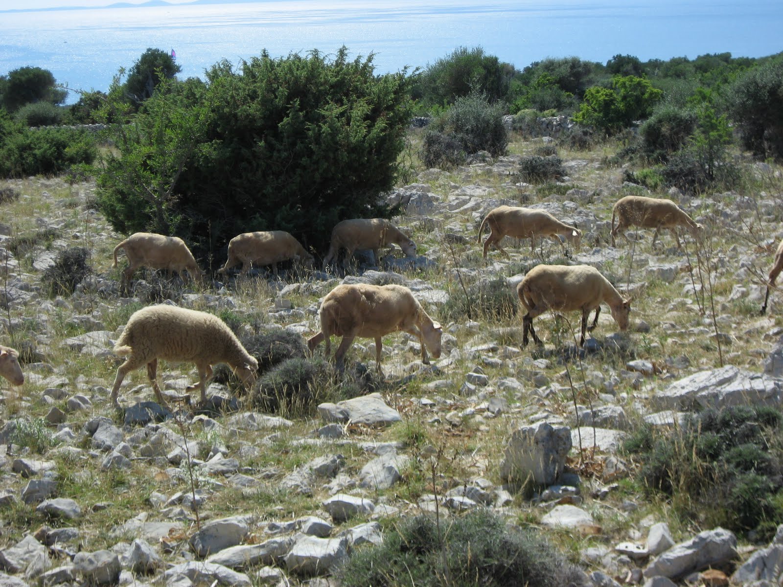
With its sheep flocks, century old olive trees, maze of stone walls to contain the sheep, cheese and olive oil traders on the side of the road, numerous Catholic monuments and amazing views of nearby islands or mountains, the Lun-Novalja section was much more picturesque and forms 2/3 of my Picasa photo album.
The road is rolling and wasn’t too busy at the end of June (August is said to be the highest season). Between the photo stops and the burning sun (82F with dry air), I was running quite slowly and it took me 2 hours to cover the 13.1 miles from Lun to the harbor of Novalja. I stopped at a grocery store to grab an ice cream and “gobble up” a bottle of cold water.
I found the bike route corresponding to the Circuit #1 between Pag and Novalja on the right side of the road toward Gajac (pay attention, it’s close after passing the Konzum super market). There is a sign there and another one as you pass the cemetery near Gajac, and you are on your own after that but it’s pretty straightforward, just turn left to cross the main road (106) before Kolan (don’t cross this village, the bike route goes on the other side of the isthmus before).
On the other side of the isthmus, the road along the sea is called Crnika and offers great views as you can see in my photo album before crossing Bosana and finally entering the town of Pag. I found the family at the terrace of a restaurant on the harbor; my GPS was indicating 25.6 miles, not quite but close to a marathon. And one more island explored, 999 or so to go, better start swimming in addition to running...! :-)
Again, don't miss more pictures of the Pag island in my photo album.

I did a fifth run the next day but the sharp pain in my left hamstring, which first triggered during my loop at Plitvice 9 days ago, came back and made me walk the last mile of 11. Time to rest or let's say tapper as we are finishing our Croatian tour (1,400 miles including an escapade in Montenegro and Bosnia Herzegovina) and flying back to Paris this Friday. What an amazing experience to discover, as a family, this amazing cultural maze in which Croatia found a way to own most of the sea shore in the recent redistribution of the Balkans land (check on a map, it's quite fascinating). We finished our tour by Zagreb which is very different from the ambiance found along the coast, with still very old buildings, not as well renovated if even maintained, and not so nice buildings from the communist era of the seventies in particular in the South part of the capital. Everywhere, the Croats have been friendly and helpful albeit the very limited use of English, even on signs/signage, and we found them working very hard and long hours (stores opening early and closing at 9 or 10 pm for instance). A huge thank you to our friends Hervé and Sylvie who provided us with their hospitality and this opportunity to discover 3 new countries and cultures! A destination highly recommended, by car or by boat, rather than on bike (we did see a few bicyclists but did not find the roads appropriate for that). And, what ever way you chose to come and visit, my last 4 posts (Plitvice, Dubrovnik, Zadar-Vir and this one) are just an illustration that you will always find great places and occasions to lace your running shoes up!

Running in Croatia #3: Zadar-Nin-Vir 50K

If you stay in Zadar (~80,000 hab.), there is a nice run up North to the island of Vir. It’s mostly flat and there is a new and very nice bike road most of the 15 kilometers between Kozino and Privlaka (to be honest, I was staying in Kozino, so I didn’t run the first 3.5 miles from Zadar which don’t have a bike path along this very busy road, 306).
I crossed the small island of Vir down to the lighthouse (Lanterna), a section which included a few miles on a rocky trail after leaving the village of Vir and passing the cemetery. Once back to our friends' apartment, my GPS indicated 31.2 miles (50 kilometers) for the out and back (from/to Kozino) and, with only two bottles, the very dry air and temperatures close to 90F in the middle of the afternoon, I had to stop at two cafes (Vir, Privlaka) and one gas station (Zaton) to get them refilled. Here is another nice church you can see from the main row, near Privlaka:
Whereas most of the Croatian coast is rocky, Nin is famous for its sandy lagoon which attracts families with youngsters as bathing is easier and less dangerous for them.
Nin has also mud pits which we experienced with the family the next day.
 Another good long run albeit slow with the heat and a nagging pain in my left hamstring. Not quite the hard training I was envisioning for the upcoming World Masters in 3 weeks, but always important to listen to your body and not push too far, too fast (in reference to the name of my blog...).

Running in Croatia #2: fortified Dubrovnik

The old city of Dubrovnik is a jewel for its architectural unity and the consistency of its renovation. Not only it had to cope with centuries of tumultuous history but also been rebuilt after the recent Homeland War (1991-1995) which destroyed several buildings (fires) and many roofs (bombs). But, it is such a touristic asset that the Croats worked hard and the buildings are so well restored, from the narrow back streets to the impressive city wall, and apart from the tourist crowd, it’s like you are transported back in time, centuries ago (same feeling I got when visiting the Palace of Diocletian in Split).

Pictures are still uploading as I post this blog on a slow connection in Zagreb, but you can already see a few in my Picasa album.
If you are stopping by Dubrovnik on a cruise, a very popular destination with huge cruise ships in and out every day (in around 8:30 AM and leaving by 4 or 5 PM), and want to “escape” the confinement of the boat running a few miles, then you want to aim at Lapad which hosts a small natural park, Petka, which you will catch from one of the steep and narrow streets behind the Hotel Komodor (Savska or Dunavska then Ivanska), situated on the laguna between Babin Kuk and Lapad.
At the end of the peninsula of Lapad’s, you will discover the upscale Dubrovnik Palace on the North West end. On the South side you’ll find a few unmaintained trails getting to the top of an impressive 400-feet cliff. I spent about an hour trying to find a trail along the cliff, getting my legs lacerated by bushes. I eventually returned on the fire road, then up to the radio or TV relay culminating at close to 600 feet (Velika Petka, 192 meters). Still looking for views over the old city, I continued on the fire road and ended up at the city hospital (Opca Bolnica Dubrovnik) which I crossed to get on Liechtensteineov Put before going through the Boninovo area along the sea, down toward Dubrovnik Grad (the old and fortified city).
With the crowd in the old city, I don’t recommend entering the city walls to run inside, nor running on the walls (2 kilometers, 70Kn fee). You should do it before or after your run. If you stay in Dubrovnik, you actually want to avoid the morning when several thousands of tourists get to the old city at the same time from the ships.
From the North entrance of the old city, you will spot a narrow and steep staired street (Put Od Srda) which gets you to the main touristic road you entered the city from by car (Jadranska Turisticka Cesta). There, you’ll have to turn left (toward North/Split), run/walk for a few hundreds yards and pay attention to the traffic before crossing to get on a stair on the other side (no indication/signage but the trail starts on the other side of the N. Kulsilica street). This is the winding trail going up to “Sv. Srd” for amazing views of the city at 1,200 feet.
The other option to get to this unique panoramic spot is to drive through the small village of Bosanka (South-East of Dubrovnik) or take the cable car from downtown. At the top of the mountain is a fort which was central to Dubrovnik’s resistance during the Homeland War. It actually hosts today an exhibit on these deadly and dark 5 years (1991-1995).
I came back to my starting point in Babin Kuk taking the road through Bosanka (another area to find quiet trails) and going through Dubrovnik and along the harbour (Gruz) to complete a 15-mile convulated loop around and across this historical city which, outside of the small fortified place, looks like a cheaper and tiny version of Monaco, with buildings hanging on balconies created on this steep and rough cliff.


Thursday, June 23, 2011

Running in Croatia #1: spectacular Plitvice water falls

I concluded my last post mentioning that my ability to keep you posted about our trip through the Balkans might be impacted by network connectivity. Not only the wifi connections we had in our first two stays were not as fast as the one we have at home, but work also came in the way and I had to spend a few hours in the evenings to work on last minute and special projects. With that, here is a quick and short one to mention a wonderful run I had in the Plitvice National Park in Croatia on Monday.
Because of the limited network bandwidth, I am not able to upload the 150 pictures I took from my run in this amazing park made of a dozen of lakes at different elevations and hundreds of natural falls in between with crystal clear water. Here is a web site where you'll find some information about the park as well as a photo gallery you can enjoy while I'm able to upload my pictures on Picasa.
For the runners, this park represent more than 20 miles of trails. The first miles are very busy with thousands of tourists at least in the high season but, as you progress toward the upper lakes and let the tourists take the boat, you'll find pristine and quiet trails with amazing views of the falls and lakes with emerald and turquoise colors.
The park ticket has a very convenient map on the back side which is enough to navigate the maze of trails around the lakes in addition to signs showing the handful of recommended circuits. The longest one, K, didn't appear long enough for me so I decided to go around the last lake at the end and top of the park. Like for the other lakes, I decided to run anti-clockwise: because this trail is not open to the public, the trail was not maintained but good enough for a good hike. Later in the evening, the owner of the apartment we had rented nearby, a ranger working in the park, told me that bears lived in this area, so be careful if you too want to explore this remote lake. By the way, you'd want to know that, after you circled around half the lake, you'll get on a road (asphalt) which will get you back to the civilization (in other words, don't try to look for a trail on the other side of the lake, I did spend quite some time and at least an extra mile to figure that out as it wasn't clear on the map). Overall, I ended up covering 19.5 miles and taking 150 pictures, quite a tour (you can check about 100 of them in my Picasa album)!

For non-runners, the park offers many options to hike from one to ten miles to enjoy these amazing natural water falls. Make sure not to miss this wonder if you visit Croatia!