Monday, June 27, 2016

Marathon du Mont Blanc: the other huge ultra running party in Chamonix

6 races, 65 nations represented, 7,000 trail runners, what an ultra party! And it was this weekend, and I was in Chamonix, what a great opportunity! Yet I didn't race, oops!

Of course, this has to see with my stroke of March. As soon as our summer plans started taking shape in February, I had applied for a preferential entry which I was eligible for but got the reply a few days after the incident. While the medical investigation was in full swing, I was already wondering if I could run again, even more so racing again. As the various tests kept coming back negative, I started forming hopes again but Agnès put that race on the not-negotiable list (I wanted to run the grueling 80 km which has more than 6,000 meters of cumulative elevation!). Besides, I would have had to get the medical release required to race in France which was unlikely back in March in the midst of that medical investigation.

Fast forward 3 months and I'm actually very glad I didn't enter. While the weather was amazing for that race, on the hot side as a matter of fact, and missed a huge storm which stroke a few hours after the last runner got in, I was able to test some of the hills and, like on the UTMB (Ultra Trail du Mont Blanc), these are some very serious trails! Not only am I behind in my hill training compared to my best years but the thing I'm mostly struggling with are the rocks and roots which make even hiking up difficult and tiring. No wonder most of the trail runners here use poles and that also explains why most of us, Americans, struggle in races in the Alps: much harder physical and mental challenge!

Back to the title, the event started a few years ago with the marathon distance and, given the popularity, added a few shorter distances and an ultra, the 80 km (50 miles). Another highlight of the weekend is the explosive 'kilomètre vertical' (vertical K) which consists in climbing 1,000 meters (3,281 feet) in the shortest time possible (the trail follows the straight line of the Plan Praz gondola!).

I was able to run the first part of the 80K course which starts with a big climb to the Brévent via Bel Lachat, that is 25% of the total cumulative elevation in less than 6 miles (11% of the overall distance)! Quite a warm-up to wake you up, better taking it easy given what's ahead in the race!


I left at 8 am, that is 4 hours after the start of the race (4 am) and it was already quite warm. To my surprise though, I discovered there was still a lot of snow on each side of the Brevent and I wasn't well equipped with my road running Brooks Launch shoes, oops!


Thankfully I wasn't racing as it took me 2 hours and 10 minutes to reach the top which the top runners get to in 1:20... But, for a change, I also took the time to enjoy the breath taking views of the Mont Blanc on the other side.


I've never seen so much snow on the Brevent this late in June, there was so much that you could have skied almost down to Plan Praz! It was good that the snow was transforming with the heat, that helped keeping my sliding under control. Yet, I never took so much time to get down to Plan Praz from the top and I was putting so much on the brakes that my quads got quite tired afterwards. Good hill training though but my hope to catch-up with the tail of the race (1,000 runners in that race!) had faded away. I made it to La Flégère where I decided to run back to Chamonix on the rocky ski run (another steep descent on the brakes some quad strength training!).


The next day I stayed mostly in the bottom of the valley and ran up to Col des Montets and Vallorcine, along the Arve river. Between the melting snow and glaciers, and the heavy rain of the weekend, I was impressed with so much water flowing from everywhere, with hundreds of creeks and falls merging into the raging Arve toward Genève and the Rhone river. You probably have to live in a dry region like California nowadays to realize the blessing of such an abundance of fresh water. Let's enjoy it while it lasts, but be appreciate for it to be more respectful of our planet and reverse the course of global warming.
On Saturday night at local friends' house, I met Laurent, one of the 80K finishers. It was great to get some first hand insider tips about that race which he ran three times and this gave me even more respect for the level of difficulty of trail races in the Alps. Once I'm done with my local Pacific Association Ultra Grand Prix (year 10 this year!), I know where in can turn my energy to...! ;-)


Running in Scotland #5: Callander and the Great Tossachs Path

Callander is one of the doors into the famous Loch Lomond and the Tossachs National Park, not far from Glasgow and Edinburgh. For us coming from the Northwest and finishing our tour in Edinburgh, it was an exit  of that park where we spent our last night in Scotland this time. We actually entered the park in Tyndrum and drove down along the whole West shore of Loch Lomond, the largest pool of freshwater in Great Britain (by its surface).

If you visit the area, make sure to get this map, it shows 8 major trails:
  1. John Muir Way Cycle Path
  2. West Loch Lomond Cycle Path
  3. West Highlang Way (the one passing by the bottom of Ben Nevis and finishing in Fort William)
  4. Rob Roy Way
  5. Three Lochs Way
  6. John Muir Way (not the same I ran on from Edinburgh!)
  7. The Cowal Way
  8. The Great Trossachs Path


It's that last one that I ran 13 miles on, Saturday morning before driving to the airport. A few steep and long hills but a super smooth trail on the 6.5-mile section from Callander to Brig 'o Turk, with great views over Loch Venachar.


We had stopped by Loch Katrine on our way to Callander on Friday afternoon and walked along the Loch for a couple of miles of asphalt so it seems that this trail is very runnable overall. All in all it covers 30 miles from Callander to Inversnaid on the shore of Loch Lomond.


Great way to conclude our trip. As you can see from this post and my previous ones in that series, Scotland offers hundreds of miles to hike or run. Most of them are hilly though. In Scotland, they don't talk about hikers but... hill hikers! Likewise, this is an amazing place to do some serious... hill running. Highly recommended destination then, rain or shine!

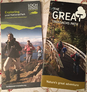
By the way, here is a brochure available for free at the many Scotland Tourist Offices, which has a few pages on each region from an hiking standpoint. Some good information to help you plan although most of the highlighted trails are walks a few miles long.


Of course, there is a lot of information available on the web too and I hope these posts help you planning your own tour of the West Highlands!


Again, I highly recommend visiting Scotland for its amazing trail running opportunities but also very welcoming people! And, hopefully, they will decide to remain in Europe...

Sunday, June 12, 2016

Running in Scotland #4: Glen Etive and Glencoe

After Fort William and the Ben Nevis, our tour of the West Highlands continued with a 2-night stop in Ballachulish, a good place to explore the nearby valleys of the Glen Coe area.

Following the recommendation of our host the night before, Agnes dropped me just after the pass of Glencoe so I could run along the Lairing Gartain toward Dalness while she would take the next road along the River/Glen Etive. The beginning of the trail was very nice, but easy rarely lasts for long on trails in Scotland!


The trail was only 5 miles so I took a detour to climb along the torrent coming down from the high ridge called Buachaille Etive Mor.


Once I got to the ridge, I veered to the right to climb the closest peak, the Stob Coire Atrium (941 m, 3,087 ft). Not much higher than the 2,800 feet of Black Mountain in my Cupertino backyard, except that the trail was less than a mile and it took me about an hour each way, that killed my average pace, I don't recall ever moving that slow, at 23 min/mile... Short of time, I missed the opportunity to climb another 1,000-meter summit. I was quite close to the top of the Stob na Doire (1,011 m) but that seemed like another 30 minutes with all these lose rocks.


Did you know that there are 282 of these summits over 3,000 feet in Scotland and they are named munros after Sir Hugh Munro? And a challenge is to climb all of them of course: the Munro bagging!
With this climb I'm done with two (Ben Nevis on Tuesday), better not aiming at this challenge or I'll regret to have missed that other reachable one as number 3!

Here is a nice detailed view provided by the Hill Bagging web site which lists more than 19,000 hills in Great Britain!

The rest of the trail down to Dalness was also very narrow, technical and slippery, so much that it took me about 2 hours to cover 10 kilometers, making Agnès wait much more than she wanted...


In contrast, I covered the next 7 miles on the uphill road in 44 minutes! This road is one single lane but the traffic was quite reasonable, even in this second week of June. It offers amazing views of the Glen Etive valley and a few opportunities to cool down in the river which has a few falls and pools (opportunities to stop on the side of the road may be sparser in the high season of July and August). Here is my Strava activity in case you are looking for a run in the Glencoe area.


That made for a good tour of what is called the Royal Forest on detailed maps although, like many other places, the forest must have been heavily harvested because that didn't look much like a forest to me. For one thing, trees don't grow over about 500 meters, so all the peaks are just covered with grass. And rocks too, a lot actually.

And to illustrate how the weather can quickly evolve, here is a view of Stob Dearh hill (1,022 m) on Thursday afternoon (the first hill of that National Forest range).
And the next day, from the same spot.
Not quite the same shape and view of that mountain, nor the same climbing conditions!

Indeed, after a week of sunshine, we finally got some good rain on Friday while driving to Loch Lomond, a much more typical Scottish weather!

Friday, June 10, 2016

Running in Scotland #3: Ben Nevis and West Highland Way

Oh no, I didn't run the whole 96-mile long West Highland Way this Tuesday! Actually, including the ascent of the Ben Nevis, the highest mountain in Great Britain, that would make quite an epic 100-mile event.

Staying at a B&B just a few miles North West of Fort William, I started by climbing to the top of Ben Nevis, about 10 miles out and back from the Glen Nevis visitor center. There is certainly nothing technical on the main route which is actually called the Tourist Path or Mountain Track, yet it's quite some slope to climb from sea level to 4,400 feet in less than 5 miles! The trail is quite rocky, alternating sections with large rocks and others with small lose and sharp rocks.

The climb actually corresponds to a race, each September. The course record for the out and back (not sure if the race starts at the visitor center) is 1:25:34 for the men and 1:43:25 for the women!! I wasn't racing of course, yet I did sweat a lot despite making to the summit in 1:35 plus about an hour to run back... Yet, even with this pale performance, I passed many many people on both ways!

Here are 4 shots taken by Agnès who climbed Ben Nevis too, despite her hip issue (which made the descent even more difficult for her...)!


After this great warm-up (it was chilly at the top but very sunny otherwise), I continued on the West Highland Way toward the South, on the Fort William-Kinlochleven segment. This trail too is the course of a trail ultra marathon race, in June. The 15-mile section I ran had everything from some asphalt while going through Fort William and Kinlochleven, to smooth fire/forest roads, to very narrow single tracks and quite a few miles of exposed and very rocky jeep roads. I didn't see any other runner but quite many hikers including a few with their fully loaded backpacks. I'm in awe with this way of traveling for several days, I so much prefer to run without carrying anything. Yet, as I had left with only a chocolate bar and 2 small packs of GU blocks, I ran out of energy, hit the wall and wished I was carrying more myself... With that, I was relieved to find a Co Op food store in Kinlochleven to refuel after these 28 miles and 6,250 feet of cumulative elevation. Also glad that I got enough coverage there to text Agnès to pick me up (needless to say, there isn't any GSM coverage between Fort William and Kinlochleven so you are on your own on the trail, except for a few fellow hikers and many sheep).

Here is a large map of Scotland to situate the run:
And a closer look at my run from Fort William (actually 2 miles North, at the entrance/start of the Caledonian Canal) to Kinlochleven, via the top of Ben Nevis:

And a few more pictures (my camera stopped working at the top of Ben Nevis due to the humidity of the cloud at the top and/or my sweat...).

The first locks of the Caledonian Canal in Corpach


 A kids race in Caol:
 The crossing of the River Lochy between Caol and Inverlochy:
 The beginning of the trail to the top of Ben Nevis
 The cloud around the top of Ben Nevis (9 days out of 10!)
 The smoothest section of the trail at around 2,000 feet

 The lake which you can see half way is called Lochan Meall an t-Suidhe (must be some Gaelic)


A large patch of snow which was fun to cross with my slick Brooks Launch running shoes...
 View of the summit
 Did it!

 A few scenes of Harry Potter were shot here! This is also a most arduous route for real climbers (I saw two on that face)
 Another view at the top
One 1/3rd of the way between Fort William and Kinlochleven, the West Highlands