In French, GR stands for Chemin de Grande Randonnée, the top National label for hiking trails. GR 223 covers the entire border/littoral of the Cotentin and the department of the Manche. I already covered this section back in 2008 when I attempted to run a self-supported and solo 100K from Granville to Cancale, in Brittany, but stopped after 53 miles. 5 years later, in 2013, I logged 100K in a few days on that trail.
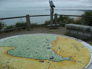
This time, I had only 4 hours before a family lunch so I just aimed at running a marathon. My favorite spot on this section is when you first see the ultra famous Mont Saint Michel when passing the Cabane Vauban after crossing the picturesque Vallée du Lude, just South of Carolles.
Then, if you keep going South, you'll get really close to Tomblaine and Mont St Michel, at Bec d'Andaine, where many people cross the Bay when the tide is low (you need a guide to avoid the famous quick sands, a real threat here).
Here are a few pictures of this segment of GR 223. Some sections are overgrown, some are quite technical (very irregular rocks), some sections have deep/soft sand slowing your progression, overall, as its name states, it is more a hiking trail than a running trail. While I had originally planned on going as far as the Pointe du Grouin, I turned back at the Bec d'Andaine, and used the road to come back to Kairon to meet the family. Only 25 miles this time, more next time...
A couple of miles South of Granville, the GR coming from La Crête:
View toward Carolles, with the beaches of Granville-St Nicolas, Kairon and Jullouville:
The Roc of Granville in the background (lighthouse):
Granville from the beach of Jullouville:
Race horse training:
Carolles-plage (Granville in the distance):
Crossing the Lude Valley (Vallée du Lude):
Climbing up to Cabane Vauban:
Caban Vauban and Mont St Michel in the background:
The view of Mont St Michel from St Jean-Le-Thomas:
Not everybody feels the urge of running...
Monday, June 29, 2015
Subscribe to:
Post Comments (Atom)


.jpg )

No comments:
Post a Comment