10th consecutive year I toed the line of this early August event: I was so excited I had to post something on Facebook the night before. And what a night... After flying back from South Korea and Japan where we stayed for 13 days, and with the 16-hour time difference, I was seriously jet lagged this weekend. On Friday, I worked at the office from 8am to 12:30am, went to bed on Saturday morning at 2am and woke up at noon, oops! I always like to put a few hours of sleep in the bank, 2 nights before an ultra, at least I had this taken care of. But with that, I barely slept 4 hours the night preceding the race which isn't that good. Apart from that, I was feeling great after logging 123 miles while in Japan, including a few hilly long runs. And I was so much looking forward to a redemption race after the DNF at TRT, this time with a distance which is my sweet spot: that was my 58th 50K race today, in 10 years. And in these 10 years, I've ran each of the Skyline 50K edition, an event which is said to be the longest running 50K event in the US with 35 or 36 editions (co-race director, Adam Ray, wasn't sure, and Gary Wang has 32 years on his RealEndurance reference website, but Stan Jensen 36 years indeed on his run100s.com page).
With 269 running races in my log, I've given away many t-shirts, but there are a few events I like collecting Ts of, like Ohlone, my fetish race, Miwok, Western States of course and this one.
After this hectic night, the day started early as I arrived at the Chabot Lake Marina in time to see the 6am early start. I apologize for not staying until the last runner gets in, but I like this opportunity to see the ones who are going to battle the cut-offs and leverage this opportunity to start earlier, a nice option offered by a few race directors.
Here is Race Director, Brian Wyatt, giving his pre-race briefing/instructions before sending a dozen or so runners on the trail.
Meanwhile, there was this wonderful volunteer who was handling the bib pick-up all by herself! (Here seen as serving our very own John Brooks.)
The venerable Quicksilver ultra racing team members, Jim Magill and John Brooks ;-)
We started right at 7am but going on the North shore of the lake this year because of some construction at the dam. I had looked at the map but admit that I'm not familiar enough with all these trails to have internalized the course and was going to rely on course markings. Fortunately, there were plenty of these pink ribbons, plus a myriad (maybe 20 total) of Park volunteers at major intersections, that was very helpful to remove any doubts.
A bunch of runners from Excelsior were at the front when we started (Brian, Karl, Jason, and more), two other runners with blue tops whom I didn't know, and Chris Calzetta and I from Quicksilver. I've seen way faster and even crazier pace in the past, so the 6:50-7:00 min/mile we were at didn't seem unreasonable. I actually pushed the pace a bit in the first climb and Chris was the only one to respond and follow. I've such found memories from running these trails with Chris back in 2011 (Skyline and Firetrails) it was a delight to run a few miles again together, although I had no illusion that this would last for too long as he got stronger and faster these past years. But, between my faster speed in the downhills and his stops at the aid station (and me not stopping), we kept going on and on until we arrived together at the turnaround, the Skyline Gate aid station around mile 14.5. The excitement of still being in the lead about half way in the race even doubled as we got welcomed by Greg Lanctot, our Club President, always providing a ton of motivation and encouragement through his radiating energy. Here are 2 shots he captured of us at this station which, I learned later, was manned/hosted by our Quicksilver Club; thank you club mates!
With the third runner on our heels, we did not have the luxury of spending much time to recover and were quick to leave. I had planned on refilling my GU2O bottle but I had only used half of it anyway so not the right time. But that showed that I hadn't not drunk enough electrolytes, and even less water, despite a good sweat as I was still wearing my arm warmer/compression sleeves. A few people had told me it was going to be chilly but the temperature was actually quite nice despite the overcast. Sure enough, the low fluid intake translated into some cramps as we were flying down French Trail and, on the next steep uphill, I told Chris 'go for it!', meaning I couldn't keep up with his pace anymore. I drank much more in this section and took 2 more S!Caps plus a pouch of Vespa concentrate. I didn't mention above that we reached Skyline Gate in 1:45 which appeared to me like a slow time compared to previous years. I was so confused with the new trails we took in this first part that I couldn't figure out if and how much that first section was harder. Passing through mile 16 after 2 hours of running, I started to doubt that I will break 4 hours today, which was my biggest objective today (out of 9 editions, I missed 4 hours only twice but for injury reasons). Better keep pushing for the last 15 miles then and, the cramps persisting, I could predict some trouble and suffering...
This time, I arrived at Big Bear (mile 20) with empty bottles, having forced myself to drink much more than in the first half. A few volunteers helped me refill them, and I also drank a large cup of Coke, getting some sugar before the next big climb. I was very pleased to have the stamina to run/jog the whole hill, still no walking so far! I had to stop at the top of the hill though because of a severe cramp in my calves, but was able to keep the cramps under control in the descent to Bort Meadow (mile 23) where I didn't stop again (sorry George Rehmet and team...). I felt good when the volunteers told me that, like at Big Bear, I was just 2 minutes behind Chris. With this boost, I maintained a good pace until about mile 25 where I realized that, unless the end of the course was cut short, it was going to require running sub 7 min miles to break 4 hours, darn! I did walk a bit but not too much, however my running had slowed down. When I finally reached the final aid station, welcomed by ultra volunteer Stan Jensen who was recording our splits, I realized that I had less than 18 minutes to cover 3 miles, which wasn't going to happen. Yet, I flew through the aid station to keep moving and protect my second place, telling to myself that, to balance the deception of missing the 4-hour mark this year, I should at least cherish these podium opportunities given my age (and it surely helps that the faster and younger dudes typically popping up at this event didn't this year!).
I had not seen anyone behind Chris and I for 15 miles since the turnaround but, bingo, one runner passed me at mile 29. I had no intention to counter, still content with third place but when, a mile later, I saw a runner with a yellow singlet (Excelsior) closing on me, this gave me a kick and got me to sprint the last mile this time. Oops, does that imply that I'm competitive? Yes, some times... ;-) Well that worked, I managed to finish in 3rd place overall, in 4:07, and I'm glad I did because 3 Excelsior runners crossed the finish line within the following 2 minutes! Dang, so long for the Grand Prix points because Loren was third for our club but quite behind. [Photo credit: Eileen Francisco]
Chris had won the race this year in 3:55. Here is the 2016 men podium:
When I shared my disappointment about my finish time with Brian, he said that he thought the new course had between 1,500 and 1,800 more feet of elevation, that surely counts. I look forward to hearing about what others have found from their GPS recordings. And that being said, I know that I may have to live and start accepting slower times, especially with my stroke hiccup of last March...
3rd place earned me a nice cap from event sponsor Victory Sportdesign. Although I was sorry he couldn't run today because of a cold, it was great to meet and catch-up with Victor again (and Lorna and Lucy). Hope everybody stopped by to check Victor's latest invention, a super organized and handy sport bag/luggage which can be carried as a backpack. If you missed the opportunity, make sure to check his website!
Special mention for Joe Swenson, another Quicksilver teammate, who becomes the second runner with 17 Skyline 50K finishes, equaling Barbara Elia's record. At the finish, Joe said he is going for 20! (Assuming he keeps running consecutive years, in two years he'll have run half of the editions...)
Big kudos to Brian and his Scena Performance team for perpetuating this great tradition and maintaining the very high standard of this event. As a side note, I chatted with two runners who were visiting from France and were impressed with the quality of the markings, the number of course monitors, the quality of the food at the aid stations and also blown away by the helpfulness and the kindness of the volunteers everywhere, their ears not believing the loud encouragements that they received when entering and leaving the aid stations. Great testament to the quality of our local races from a fresh perspective. Indeed, volunteers, you rock!!
What I also like in this event is that it marks for me the start of the second half of our ultra running season. Indeed, there have been so many great ultra accomplishments by many already this year, but we are barely half way, Summer isn't even over yet, let's keep running! And see you on the trails then...
Monday, August 8, 2016
Monday, August 1, 2016
Running in Japan: Noboribetsu Onsen in Shikotsu-Toya National Park
I'm not sure this is going to be a very popular or useful post. First, this Japanese National Park is really not on the beaten paths for foreigners, least so for runners and likely not for my blog followers. Second, we had such a bad weather for our whole stay, we couldn't see a thing which is quite unfortunate given the exceptional scenic landscapes this active volcanic area has to offer. Yet, I found so little help to prepare my runs while we stayed in this Park, I hope this will be useful to some people... And to provide a nice virtual visit of this part of Hokkaido in case you don't have the opportunity to visit, I even included a few videos for once. Now making for a long post by combining 3 long runs...
The Park is given as the 14th largest of Japan's National Parks and is the closest one to Sapporo in Hokkaido. There is even a direct bus shuttle from the New Chitose International airport to Lake Shikotsu and numerous trains riding along the Pacific Coast of this western Peninsula of Hokkaido. With some persistence, Agnès even found a shuttle between downtown Sapporo and our first hotel in Noberibetsu Onsen.
Our first stop in Noboribetsu was at the tourist center when I asked for a map of the trails. We were helped by a Japanese person speaking a perfect English which has been quite rare during our week in Hokkaido. While she was very nice, the indications she gave me were quite disappointing as she kept pointing to the 'trails' of the Hell Valley, trails which length were given between 229 and 599 meters (Japanese like precision, don't they?). When I mentioned that I had run 30 kilometers the day before, she almost rolled her eyes and added that that's all it was in the area, that even the road going up to the famous Lake Kuttara was closed because of the bad weather and danger of mud slides.
Well, a couple of hours later, I left the Hell Valley and hopped on that road which was actually better than any of our roads in California. The asphalt was so slick it made the climb up that first volcano quite smooth and easy, it felt like being on a Formula 1 road circuit! However, yes, the weather was quite bad, alternating between pouring rain and fog; so long for the view and the pictures... Here is the view I got of Lake Kuttara, from the shore of the lake and from the ridge of the crater. I told you, I couldn't see a thing...
Not quite as nice as the picture of that lake you can find on Wikipedia:
I was also excited to run in circles around this almost perfect round shape (see below on that terrain map from Wikipedia too), but I was disappointed that there wasn't any trail along the ridge as a matter of fact. No wonder why the water of this lake is so pure, humans can barely access it, that's the way to protect the environment and the key to sustainability!
With that, this lake remained mysterious indeed to me, like the posting was indicating anyway...
As for the fire danger posting, that looked really weird; I'm really not convinced any fire could start in such a lush vegetation which looks more like a rain forest! Mind the observation of a Californian who feels sad for the terrible wild fires going on in California this summer again...
Anyway, after the initial 3 miles to get to the lake, I continued for another 36 miles on this road and turned back at the large gate protecting me from any car and bus traffic which I imagine would be important on a nice day.
From a running recommendation standpoint, there are a few narrow sections on that road where you'd have to be careful if two mega buses cross each other. But otherwise, there is a good marking on each side which leaves some room for foot and bike traffic.
And the danger doesn't seem to be bears in this area, but fox! ;-)
On my way back down, I found a few signs, in Japanese, indicating a trail passing by another lake (from the picture), and a 4.4km distance.
Too tempting to pass on the invitation, I went on that trail, which looked really nice, at the beginning...
I was already soaked from the rain, humidity and sweat but that got worse: running creeks, wet leaves on each side of the trail and mud swamps got the soaking to another level! I had to spend some time in the evening drying my running shoes with the hair dryer at the hotel...
With the approximate picture of the above trail map in my mind, I ended up on the wrong trail and turned back when my GPS watch indicated that I had missed my target by at least a mile. On my way back, my phone got coverage and I was able to send a Whatsapp text message to Agnès to tell her I was still ok and on my way back. To be honest I had no idea about the way to get back to the hotel at that point and glad that, short of showing a trail, Google maps was showing me which side the onsen was. After some wandering, I got back to the wrong turn I had taken and on the right trail.
Uploading my Garmin data on Strava, I could see what I did on the map and what to do to get to this lake, Lake Tachiba, the next day...
Overall, with more than 3,200 feet, some good elevation for 20 miles.
With dried shoes that Friday morning I went back in the... rain and got drenched again as I approached and did a loop around Lake Tachiba. The trail was easy to find this time but quite damaged by the heavy rain which fell all week. Luckily, as I was finishing the one-mile loop, the fog opened up a bit so I could get a glimpse of the amazing turquoise color of the shallow water.
While the nearby Lake Kuttara is said to be the second cleanest water in Japan with under water visibility up to 20 meters, Lake Tachiba has a flat bottom and the depth doesn't seem to exceed 3 or 4 feet so the water looked crystal clear. I was surprised to see quite a few fish enjoying this super quiet place. Here is a short video, sorry again for the lack of sun and blue sky...
And a few pictures of that area which must look even much nicer with more light.
In this weather, I certainly didn't see anybody during my run but, given this looks like the only major hiking trail in the area, albeit 4 mile-long, I assume a few hikers must go through this area when the weather is better. At least, and despite the obvious recent damage due to the rain, the trail looked somehow maintained.
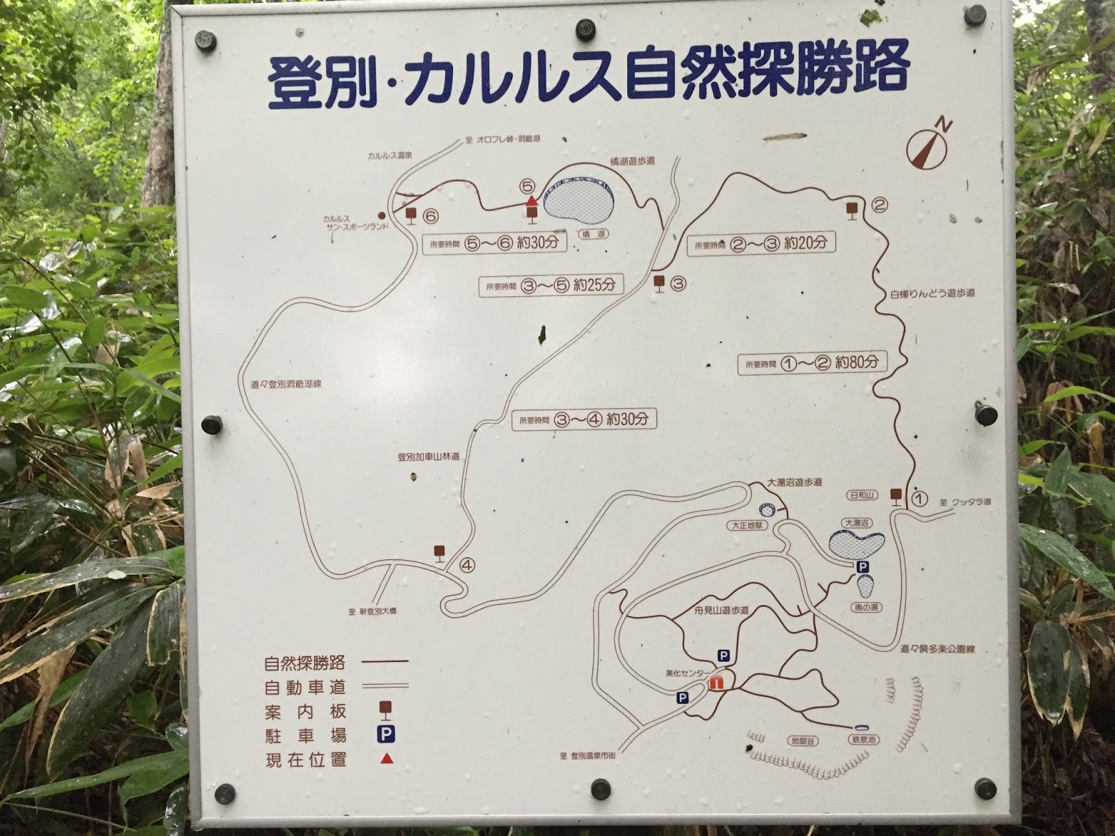
90% done with the loop I actually found this sign indicating another trail to climb out of the volcano's crater, toward another nearby onsen (in Japanese onsen means a resort with hot springs).
And this map again which is a key resource if you want to explore the area:
This other onsen though, Karurusu Onsen, was a tiny one with only one hotel. I was looking forward to finding a 7 Eleven to get some water and ice cream, but there was not a single shop to be found around. I did stop by the tiny post office where the nice owners accepted to fill up my water bottle. I came back to Noboribetsu on the road, yet another very smooth asphalt with ample room on the side to run safely against the traffic.
Back to Noboribetsu, I joined the flocks of tourists and ran and stopped by all the recommended spots, starting with the famous natural foot bath (natural spring of sulphur water between 100-110F, 40-43C):
The sulfurous Lake Oyunama:
The picturesque Hell Valley where the sulfur prevents any vegetation to grow.
And the episodic geyser Tessen-Ike with boiling water and steam:
The picturesque Hell Valley where the sulfur prevents any vegetation to grow.
And the episodic geyser Tessen-Ike with boiling water and steam:
Here is some live action in this short video! ;-)
Are you getting confused with my report yet? Here is an annotated map of my second run, mapping out some of the aforementioned names and locations...
On Saturday, our third day in the Park, we spent 3 hours to switch places, to Lake Shikotsu Onsen, on the eastern side/entrance of the Park: 1 bus down to the Noboribetsu train station, one train to Tomakomai, another train to Chitose, and a bus for the remaining 25 km up to Lake Shikotsu. Same drill, a stop by the visitor/tourist center to get local maps on which I quickly spotted an interesting challenge, running to the top of Mt. Tarumae which is a volcano still in activity, exhibiting some flumes. With a detour though the Morappu campsite, it took me 9.5 miles to get to the bottom of the volcano but, again, not seeing a thing due to the dense cloud. What a disappointment for the missed picture opportunities, yet I was glad I was able to do this quick climb before night fall as we were visiting the place for less than 18 hours...
Quite a spike on the elevation chart, up to 3,200 feet! Not for much of a view again at the top, the visibility on the edge of the crater was barely 10 feet...
And two more videos to give a better feel of the foggy experience...
You see, not much to see up there this Saturday...
Here is view situating my run on the East side of the Shikotsu-Toya National Park:
Indeed, glad to have squeezed this 18-mile run in as we had to leave early this Sunday morning to fly to Narita (Tokyo International Airport) to join Max at his Gakko camp.
And two more videos to give a better feel of the foggy experience...
Here is view situating my run on the East side of the Shikotsu-Toya National Park:
Indeed, glad to have squeezed this 18-mile run in as we had to leave early this Sunday morning to fly to Narita (Tokyo International Airport) to join Max at his Gakko camp.
90 miles in 5 days while on Hokkaido, not too shabby given the bad weather we had, and the public transportation commutes between the three places we stayed at. My reports would have surely been different would have we enjoyed blue skies and stunning views of this volcanic area. Overall, the trail running and hiking opportunities weren't as abundant as in Scotland for instance. For one thing, the Japanese are very serious about security as you can see from the road marking and the comments from the visitor centers' staff advising against venturing off the beaten paths. Second, there is obviously the language barrier which prevents from asking for directions or even reading the signs, all in Japanese. A bit disappointing in a country so addicted to ultra trail running. Speaking of which, I had considered running an ultra race last weekend but the website and registration process were all in Japanese and the race director never replied to my emails. Yes, Japan is quite a special place to visit, and not an easy one with this language barrier. More than anywhere else, you have to ask a lot of questions here...
Labels:
Running in Asia
Subscribe to:
Posts (Atom)