After landing late in Guatemala City, we had a few hours in the morning before catching a shuttle transfer to Lake Atitlán at 11 am. While preparing our trip, I wondered if it would be safe to run from the airport where our hotel was, to the historical center of the capital: short of getting any running tip online, I found a mapping of the districts, called zones, to... organized gangs. Dang! To make the matter more interesting, most maps indicate that the mapping is approximate and fluctuant. But you'll find some consensus on a safer corridor, as stated for instance in this nice piece advocating for some relative safeness in the right zones.
With all these elements in mind, I stopped by the reception of the small hotel and, seeking for some local opinion, asked: "can I run to downtown from here?" The man replies: "oh no!" Oops! I added: "is that really so dangerous?" He said: "oh no, it's too far and you have a shuttle in two hours anyway, you don't have time, you need to take a cab!" Ah, if that's all, then I can squeeze in a 10-mile run...
Beyond the zones, the city is quite easy to navigate with horizontal streets (calles) and vertical avenues (avenidas). Well, that's for the topography. From a footing standpoint, some sidewalks are high and quite in bad shape with deep holes or broken cement plaques. Better pay a lof of attention to where you put your feet. More importantly, this isn't California: priority is to car and bus traffic, not pedestrians! And then, there is still the risk of pick pockets. That means you have to remain three time super focused on your surroundings. With that, I still managed to catch some pictures on the way, again, being careful when getting my phone out. I also made sure to run against the traffic, for instance using 6A Avenida Pista Derecha to go North, toward the center, and Avenida 7A to come back to the airport. I even found a bike lane on the latter: you still have to pay a lot of attention when crossing streets, but that was a pleasant surprise.
While the city has its roots in Mayan history, as far as 1500 BC, it, along nearby Antigua Guatemala, got almost destroyed a century ago in the tragic 1917-1918 earthquakes. The resulting architecture is an old modern style, with the classic Baroque churches and large concrete-made official buildings. Between the risks, the pollution due to heavy traffic and the high elevation (4,900 feet / 1,500 m), the air didn't feel the best to get into the... zone.
Overall, and admitting I didn't see all the touristic highlights of zone 1 in particular, I'm still glad I grabbed this opportunity to have a quick look to a major Guatemalan city which most tourists avoid. Yet, this isn't the most magical capital in the world, it surely makes sense to spend more time in Antigua, a UNESCO heritage site for good reasons, as we'll find out a few days later.
If you are up for a run, then get into the... right zones, please, you've been warned! :-)
Here is a Relive.cc flyover (click on the link or the picture below):
If you wonder based on the different start and stop location, I did manage to safely get back to the hotel, and in time. Just that I reset the run on my Garmin while taking the last picture, phew!
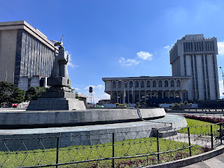
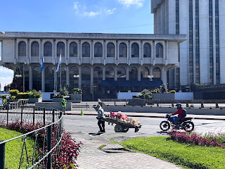
And below are the pictures used in this video, for a more static walk-through.
All these US-important brands... not for the better, in my opinion! But I got to see a goal from Croatia
Church Nuestra Señora de las Angustias Yurrita
Olympic MonumentSan Francisco Church
Palace of the National Police
Pedestrian section on 5A Avenida
Civic Center and Supreme Court
Federal Reserve, Numismatic Museum
A bike lane on 7A Avenida!
Original obelisk on Plaza de la Republica
Torre del Reformador, not quite the Eiffel Tower!
... and nuggets, grrr...
Plaza España


1 comment:
Wow! Jean....this brings back fond memories of Guate....can't wait to read the rest of your posts from there....glady you did this trip and got to see the high points.
Post a Comment