Monday, July 31, 2017

Back home for a last tune-down before Skyline 50K

After 5.5 weeks out of the country, it felt good to be back home and reconnect with my usual running routes and routine. Traveling has been amazing, with so many opportunities to see family and friends and the discovery of new places in South Africa and Namibia, but it has its toll on the running, especially when we join an organized group tour like in Namibia.

My first run after flying back from Africa on Wednesday was on my local neighborhood 5K loop, which I covered three times, getting faster and faster, down to the last mile in 5:58. Between the heat of the summer, the elevation in Winthoek and Johannesburg (5,500 feet), the steep and rocky terrain in the Alps, it has been months since I broke that pace on a mile, last time was probably during the Boston Marathon as a matter of fact. Well, except a short spike at 4:42 min/mile (!), flying down the Lion's Head mountain in Cape Town as Max noticed on my Relive.cc flyover.

On Friday, I ran 9 miles again, albeit slightly slower given the heat (92F) and the rolling terrain of our trail loop at work. And, after experimenting with much success my new pairs of Brooks Caldera since May, I broke a new pair of shoes: the other Brooks trail shoes, called Mazama (that makes 5 different trail running models with the well-known Cascadia, now in their 12th release, the light and fast PureGrit and the Adrenaline ASR 14).

On Saturday, after these two runs, I felt quite bullish and aimed at running a 50K, to the top of Black Mountain plus 3 Bella Vista/Indian Creek trail loops, which I've never done more than 2 at a time. Although I was up early thanks to the jet lag, I only left the house at 10 am and got stuck at the top of Black Mountain in the middle of the blazing heat, which I was completely unprepared for after enjoying the winter season for 2 weeks, down under. I actually had pushed quite a lot on the climb up to Montebello Road, passing 2 bikes and being passed by 2 other bikes (which is rare on this steep climb), just before the top. 

At the beginning of the first loop down Bella Vista, I ran into Chuck Wilson and we chatted for 5 minutes about many topics: Namibia and South Africa, which he visited too, Vespa, his recent switch to a low carb diet, where to find the best water in the area, etc. As I resumed my run, I started feeling dizzy but that passed after another mile of down hill. To save some energy for the next loops, I alternated running and power walking in my first climb on Indian Creek, but even walking was hard in this heat.

I stopped for 3-4 minutes at the backpack campground to refill my bottles and cool off a bit in the shade, but was still hopeful of completing the three loops. However, struggling on the second climb, over heating, I decided it was more reasonable to cut it short and return home and keep the 3-loop goal for later in August as another UTMB-prep exercise. Before hitting Montebello Road again on the way back, I still went on the Waterwheel trail detour for a total of 31.2 miles, and I stopped at every creek on Montebello Road to cool off. Despite some walking, even in the last flat miles across Cupertino, I was stunned to see that my overall average pace ended up close to 9 min/mile, I certainly had pushed too much in the first climb! It took me a few hours and a good night of sleep to recover, and I was able to run 9 miles before jumping on a plane again this Sunday morning, this time for Dallas, Texas. As a side data for this ultra experiment, I weighted 137 lb after my 2-day trip back from Namibia and 124 lb after this challenging 50K training run, quite a difference over 3 days! Thinking about it, I believe the main reason I bonked is that I only ingested 300 calories (1 Snickers bar, 1 GU gel) for the whole run; while it was a good test of how hard it is to switch to fat burning without using Vespa, it was on the risky side. Lesson learned.

The Strava map and profile (Strava activity):


Well, instead of a tune-up, I'm calling this 50K a tune-down before next week's Skyline 50K race (I know, tune-down isn't in dictionary, but that fits well with the context...). At least I got some last minute heat training, in case it's getting hot on race day. It will be my 11th consecutive participation, I've very much looking forward to it, I really like this fast course and local ultra reunion! This will be my 64th 50K race in 11 years, time flies and how much things have change that I now run a 50K to train for another one a week later... But it's more than, like many others, we use ultra races to train for bigger and longer goals (UTMB on 9/1 for me). What an ultra life! ;-)

There are quite a few Quicksilver teammates signed up, should be fun! See many of you there on Sunday (I won't show up on Saturday this time... ;-)!

Tuesday, July 25, 2017

Running in Swakopmund, Namibia: back and forth the water front

I'm just back from an amazing 6-day tour of Namibia but I had very sparse Internet connection so here is an after-the-fact post from my run in Swakopmund, last Friday.
As you can guess from this lighthouse, Swakopmund is a seaside city on the Atlantic Ocean, and here is a large map to situate it, as well as Namibia, which is still a country that many don't know much about, between South Africa, Angola and Botswana (Swakopmund is the black and white spot in the middle of the coastline).
As for the name, Swakopmund literally means the mouth of the Swakop river and shows the very strong German heritage from this ex colony (Germany lost it to South Africa after WWI). Now, what the Germans might have not realized is the actual meaning of the word Swakop, for which I'm quoting Wikipedia (Swakop River):
The name comes from the Khoekhoe languages of the Nama and Damara Tsoa-xaubTsoa means ‘excrement opening’ or ‘anus‘ while xaub stands for the ‘contents of excrement.’ This name derives from the observation that the flow of large amounts of brownish sludge in the rain with it and discharges into the Atlantic Ocean.
So, for the locals, as our great guide Gabriel pointed out, this city name sounded more like the mouth of the diarrhea... oops!
Anyway, back to running, the lady I asked for a potential long route at the front desk of our hotel said that I was in luck because there was a 20-kilometer (13 miles!) paved path along the coast, going to the North. As it was challenging to run during our group trip (2,200 km in 6 days!), this was the perfect opportunity to escape for a few hours and run a marathon! I woke up at 4:30 am and was out in the dark as it is winter down here, with the sunset around 6:30 am in July.
But, indeed, I was super pleased to find not only a paved path but a lit one, right along the alternatively sandy or rocky beaches. I told myself that even if that path was only 10-kilometer long, it was still very much worth it. However, it came to an end as I was less than 3 miles in my run, oops! I went on on the packed sand and a path resumed through a very nice park, the Paddock Gardens.


The Paddock Gardens after the fog dissipated, later in my run:


After that, no more trail but an intricate network of roads through recent and ongoing housing developments. It was so foggy in the early morning, with visibility shorter than 100 yards, that I wasn't sure which direction I was going. Luckily, I ended up on the main road, at the exit called Mile 4, which is indeed the Northern end neighborhood of Swakopmund. Because I didn't use the straight main road to get to this intersection, I had 6 miles on my GPS and decided to turn back, to avoid the dangerous traffic of C34.

I stopped by the hotel (mile 12), then went on for another round, albeit not quite to the Mile 4 intersection, so I could get ready in time for the continuation of our trip.
On my 1st way back, I experienced a phenomenon that I don't recall seeing before: a white rainbow as the fog dissipated. I was going to create a neologism for that, fogbow, but the term Fog Bow already has its Wikipedia page, of course!
Here are other views at/from the end of the paved path (around 3km North of downtown, not quite 20 kilometers!)

A nice promenade to finish my run on:
A total of 21 miles and a nice opportunity to run, not to be missed in this busy road trip.
Relive.cc's 3D flyover animation (click on the image below, then the white arrow):

By the way, shortening my run actually allowed me to get a few minutes on the Internet to post a few pictures on the Chameleon Safaris' Facebook page.
And win the photo contest!
More pictures of Swakopmund for the continuation of a virtual visit.


Running at JNB: Jones Road

My first flight out of 3 to get back home from Namibia got delayed by 3.5 hours at Windhoek so I got stuck at JNB, Johannesburg's O.R. Tambo International Airport for a night and a day. But that's not an excuse for not running, isn't it?

Now, as I mentioned in my previous posts, there are a few places which are not recommended to explore on foot, and Johannesburg is high on the list. But, when I woke up and open the curtains of my room this morning, I noticed not only the great winter weather, with blue sky and 56F/13C temperature,  but what looked like a very smooth sidewalk along the airport perimeter. That looked too good to pass on...
Well, between a busy airport and highway, and crossing a large industrial complex visited by many trucks, that's certainly not the nicest run you can experience but, again, if you get stuck for a day at this airport, it's an ok place to log a few miles. I did 11 miles.
Note the elevation chart at the bottom which oscillates around 5,500 feet (1,700 m), the same altitude as Windhoek's, and you can feel it's slightly harder to breathe.

The sidewalk doesn't go all the way but the side of the road otherwise is easy to run on.


This is the South extremity of the road, when you get to the end of the tarmac, where you can see the big birds landing (video clip).
Relive.cc's 3D flyover (click on the picture, then the white arrow to see the animation):
Here is a map ti situate JNB with regard to the city.
And, a bit of advertising at the airport...

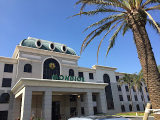
Oh, and I couldn't resist, for my family which has been so close to Christian Dior's history from Granville to Paris and around the world. South African Airlines put us in a very nice hotel owned by Peermont, with several casinos and hotels on the premises, including one called... MONDIOR!
Anyway, I should now get home 27 hours later than initially planned but I'm glad that, unlike most of the other passengers who missed their connections, I could at least get my suit case to allow me to run these 11 miles during this unexpected long stop!

Monday, July 17, 2017

Running in Cape Town #2: Waterfront and Boardwalk rather than downtown

I love leveraging my passion for running to discover the new countries and cities I visit, and share what I see for those who can make the trip. Unfortunately, there are a few places where running on your own is dangerous and South Africa is one. It's even an issue for locals and natives, even more so for tourists. On Friday, I decided to hike a non urban place, Lion's Head. On Saturday, I went to explore downtown but I quickly felt uncomfortable as, a few blocks from the financial district, I got into either entrances to highways or homeless people sleeping on the sidewalk. I was hoping to run along the Ocean on the North side but that's not an option, with the busy industrial harbor. Disappointed, I turned back and passed by the City Hall. It was Saturday morning and, except for a craft market in front of the Town Hall, the city was super quiet.

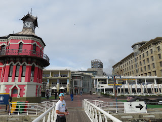
From there, I traversed a busier area and made my way toward the place all tourists end up in Cape Town: the V&A Waterfront (V&A for Victoria & Alfred). By chance, I ran into Agnès who was on her way to check if we could get last minute tickets to visit Robben Island, where Nelson Mandela and many other apartheid opponents and activists were imprisoned for many years of their lives. It was oversold already, she will go with Greg, when she is back here after Namibia. I was at least able to visit the small exhibit at the deck.


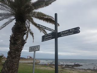
I resumed my run along the shore and found these signs for a 3.1-mile loop from the Waterfront.


I ran part of it but then continued farther South along the Ocean.


Wonderful place to log a few miles, away from the dangerous car traffic and with views of the incredibly powerful waves breaking on the rocky or sandy beaches.
On Sunday night, after our trip to Boulders Beach (to see the adorable African penguins) and the spectacular Cape Point and Cape of Good Hope, I went back on the his boardwalk and pushed to the end of the sidewalk at the exit of Camps Bay, after going through Clifton.
It was dark already (sun sets before 6 pm in winter), but I could hear the Ocean's breakers for the 6 miles (and back) so the views must be incredible all the way (the Ocean on one side and Table Mountain on the other). By the way, I ran with a headlamp, just to be safer, but the boardwalk (Cap Town) and sidewalk (Clifton and Camps Bay) have street light most of the way. There are also bathrooms in many places on this route, albeit not open at night.
Note that there is also a mile-worth of smooth, flat and straight bike path along Main Street, starting at the National Stadium.

Here are the 3D flyover videos from Relive.cc: Saturday and Sunday.


From my short 3-day experience of Cape Town, this boardwalk is the ideal place to log miles if you are staying near Sea Point or Green Point; highly recommended route if you visit the Mother City!